This section contains entries about our botanizing in Baja California written for the UC BEE (Oct 2012 to Aug 2021)
and The UC Bee Hive (2022-), monthly newsletters for volunteers and staff of the UC Berkeley Botanical Garden.
Click on any photo for a larger image.
BEE FEB 2020
Loreto and the Sierra la Giganta — December 2019
 About three weeks after arriving in Mulegé, we were free of obligations for a few days and decided to make an overnight trip south to Loreto, only 90 miles and 2 hours south. In typical fashion, we took quite a bit more time to get there because we had to stop and look at plants and the wonderfully lush, green landscape along the way.
 For about 45 miles, the highway mostly skirts the western shore of Bahía Concepción, twisting and turning and climbing and descending through canyon after canyon. At the southern end of the bay, the road climbs up through a long grade and tops the summit where the canyon opens out and descends again, revealing a wide view of the Sierra la Giganta and its sawtooth outcrops and peaks. It then continues well inland through several valleys and returns to the coast at Loreto, a town several times larger than Mulegé and home to an international airport and several medium-scale tourist resorts. It is also a gateway to the Sierra de la Giganta, San Javier Mission, and the Comondús (see the April 2018 and June 2018 issues of the BEE).
Bahía Concepción to Loreto

On the north end of the pass leading up to the microwave tower, the plants were notably lusher and greener, with a higher density of Elephant Trees (Bursera hindsiana and B. microphylla, Burseraceae).

Southern side of the summit. There´s an obvious difference in vegetation coverage between a SE facing hill (R) and a NE facing hill.

Just below the summit you are treated to a sweeping view southward to the Sierra la Giganta in the distance. One of my favorite vistas.

Late afternoon light on the Loreto Mission, the first mission in the Californias; it dates to 1697. Rocks were hewn from quarries in the mountains to the west and transported by mule trains.
Into the Sierra de la Giganta

Almost a full panorama of the Sierra la Giganta...

...along the highway to San Javier...

...and #3 of the panorama.

Climbing farther into the mountains. Elev. 150 m (c. 492 ft).

North facing road cuts had lush, dense vegetation.

One of several large canyons draining towards the Gulf.

How do they do that? I'm always amazed at where plants can grow>>>

Palo blanco (Lysiloma candidum) and Cardón (Pachycereus pringlei) doing quite well perched on the sheer rock face. Elev. 190 m (623 ft).

Hillsides with mostly north or northeast exposure are so dense there is no ground visible in most places. Elev. 253 m (830 ft).

The south to southwest facing canyon wall opposite the location of the photo on the left. The difference in coverage is dramatic.

Looking southwest. The road in the top right is the same as in the next photo.

Looking south. Getting close to the top of the grade, but still a ways to climb. This hairpin turn provides a place to pull over to look around.

Rock daisy (Perityle californica, Asteraceae), common across the peninsula. This was growing in a shady place on the steep face of a rocky roadcut.

The local Rock daisys have tacky or hairy foliage and a strong odor.

Thick-leaved Groundcherry / Tomatillo (Physalis crassifolia, Solanaceae). Flowers are about 2-2.5 cm D and pendant.

The papery lanterns (fruit) of Groundcherry
are about 2.5 cm D x 3 cm L.
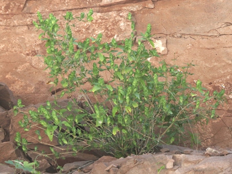
Shrubby Bractspike (Tetramerium fruticosum, Acanthaceae). These were small shrubs to about 60 cm H.
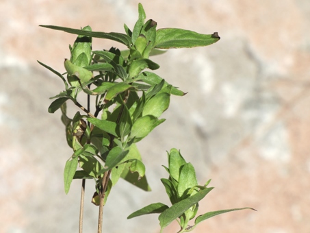
Shrubby Bractspike (Tetramerium fruticosum). There were no open flowers, but a few dry ones could be seen within the spikes' leafy bracts. Visit this Bajaflora.org page to see a lovely flower photo.

Almost at the top of the grade. The day was very still, and looking down into this deep canyon from a pullout on the highway, I was able to hear all the water flowing far below. Elev. 344 m (1129 ft).

Down there is the highway we just climbed and the hairpin curve (out of frame on the left) where the previous plant photos were taken. Elev. gain from below in the arroyo bottom where the road disappears on R side: 160 m (525 ft) .

Just below the summit of the highway. I am standing on one outcrop of rock looking across to another, with a narrow crevice in between and a drop off of several hundred feet. Elev. 520 m (1706 ft)

Vegetation here dominated by Palo Blanco (Lysiloma candidum, Fabaceae), Limberbush/Matacora (Jatropha cuneata, Euphorbiaceae), Palo Adán (Fouquieria diguetii), Elephant trees/Torotes, (Bursera spp.). There is also a Maguey (Agave sp.) and an as yet unidentified succulent-like species, maybe Hesperoyucca, as well.

Top of the grade, west of Rancho Las Parras. So green and lush!
Top of the Hill
Once at the top of the grade, the road continues through the bottom of a wide valley. The mountains are a mixture of rough lava outcrops and smoother, paler volcanic hills. We stopped along a stretch of the highway where there was an extensive mostly flat open area on one side of the highway and on the other, a gradual climb to more pointy hills. Elevation was about 540 meters (c. 1770 ft).

The scrub here was dense with Palmer Mesquite (Prosopis palmeri, Fabaceae), Elephant trees (B. hindsiana and B. microphylla), Palo Adán (Fouquieria diguetii), and Palo verde (Parkinsonia florida).

Opposite side of highway from photo on left. The low dark tree is Palmer Mesquite (Prosopis palmeri). Interestingly, there were many shrubs that looked like Palo Adán, but were in fact Brandegee False-Ocotillo / Pimentilla (Adelia brandegeei, Euphorbiaceae).
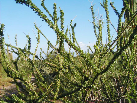
Like Palo Adán, Pimentilla has stiff, whip-like branches but they do lack the axillary spines.
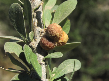
Pimentilla's leaves are also clustered along the stems like in Palo Adán, but the fruit are typical of Euphorbiaceae.

A delicate, annual morning glory/Trompillo trailing along the ground. Ipomoea sp. (maybe I. purpurea, Convolvulaceae).

Morning Glory/Trompillo (Ipomoea sp.; maybe I. purpurea).

Chuparrosa (Justicia insolita subsp. insolita, Acanthaceae), an endemic shrub found from the Sierra Guadalupe (W of Mulegé) to around La Paz.

Flowers of Chuparrosa are fuchsia to purple and about 2 cm W.
Aquatic Plants
One of my goals for the trip up the highway toward San Javier was to reach a place to look for aquatic plants and mosses. I knew that there were several places where a stream crossed the road and I wanted to go at least that far before we had to turn back to Loreto and home to Mulegé. A few kilometers after reaching the top of the grade, we came to the first good place to search at an elevation of about 520 m (1706 ft).

Water crossing along the highway. This was as far up the road as we went. Instead, I spent some time looking for moss and other plants.

Small pools feed a variety of plants, such as the Cattails (Typha dominguensis, Typhaceae) seen here.

Arizona Foldwing / Huachichila, Alfafilla (Dicliptera resupinata, Acanthaceae). The flowers are 1-1.5 cm L, the bases enclosed tightly in two leaflike bracts. They range from at least Mulegé south to the Cape.

False-daisy / Clavel del pozo (Eclipta prostrata, Asteraceae) and Blue Streamwort (Stemodia durantifolia var. durantifolia, Gratiolaceae) have managed to take root under the ledge of a rock slab.

The shallow pools formed on top of the rock slab were home to Stemodia, Eclipta, Eleocharis sp., mosses and Showy Monkeyflower (Erythranthe floribunda, Phyrmaceae).

Moss, Eclipta, Stemodia and Eleocharis sp. (Cyperaceae) take root in the dirt at the base of Buffelgrass clumps (Cenchrus ciliare Poaceae).

False-daisy / Clavel del Pozo (Eclipta prostrata). The flower heads are quite small, about 8-10 mm.

Purple Scalystem / Cordoncillo (Elytraria imbricata, Acanthaceae). Flowers are borne in scapes and are each about c. 5 mm W x 5-8 cm L.
More photos from SEINet.
It was a fun trip with lots of pleasant surprises: tiny flowers, lots of water and flowing streams, wetlands, moss, and so much green. I wished we could have stayed a few days up in the mountains, but obligations called. So that's it for this month, but I hope to keep up the field trips and to share our finds from here. So, until next month, hasta la próxima…
Debra Valov—Curatorial Volunteer
References
Rebman, J. P., J. Gibson, and K. Rich, 2016. Annotated checklist of the vascular plants of Baja California, Mexico. Proceedings of the San Diego Society of Natural History, No. 45, 15 November 2016. San Diego Natural History Museum, San Diego, CA. Full text available online.
Rebman, J. P and Roberts, N. C. (2012). Baja California Plant Field Guide. San Diego, CA: Sunbelt Publications. Descriptions and distribution.
Wiggins, I. L. (1980). The Flora of Baja California. Stanford University Press. Descriptions and distribution.


