This section contains entries about our botanizing in Baja California written for the UC BEE (Oct 2012 to Aug 2021)
and The UC Bee Hive (2022-), monthly newsletters for volunteers and staff of the UC Berkeley Botanical Garden.
Click on any photo for a larger image.
BEE JAN 2019
Sierra de Guadalupe y Sierra Zacatecas (Mulegé, BCS)
 Very soon after we arrived in Mulegé in late October, our friend Javier and I rode in his dune buggy up into the sierras west of town. While the lowlands around town and Bahía Concepción were quite dry, the surrounding mountains looked velvety green from a distance. I was on a moss and fern hunt, hopeful because Javier had told me there was lots of water everywhere.
 in the Baja California Plant Field Guide (Rebman & Roberts 2012).")
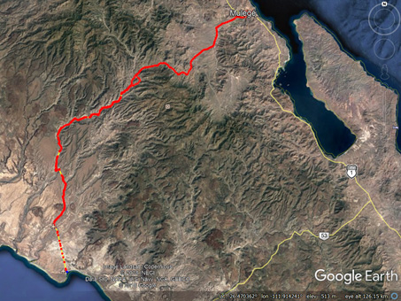
Unlike the trip we made together to the southernmost part of the valley via Arroyo las Chuparrosas in Nov. 2017, this one took us out of the valley and well into the sierras to the west via the main road that, after an additional 70 km, eventually ends on the pacific coast at La Ballena (see map above left; click image to enlarge). Our trip took us almost half-way across the peninsula.
As we made a turn towards the west out of the main arroyo that runs north-south along the Mulegé Valley and started to gradually gain elevation, the vegetation that we passed through on the bajada (alluvial fan) grew increasingly thick and leafy. Just west of Rancho la Trinidad (at 150 m, 492 ft), we left the Central Gulf Coast ecoregion (reddish brown on map, right) and entered the Sierra La Giganta ecoregion (violet on map, right) as we we started to climb and passed 200 m elevation (656 ft).

Track from downtown Mulegé (top, far right) across the valley to the San Miguel Panteón (=cemetary; bottom, far left). One way trip: 47 km (29 miles).

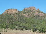
As we crested that first ridge, the mountains opened up before us, revealing Arroyo San Patricio and the peaks and mesas forming its walls. Everything was so green, all I could say repeatedly was “wowwww…”. Javier pointed out Mesa Zacatecas which forms part of the southern side of the arroyo.

The road travels along the northern side of Arroyo San Patricio, eventually dropping into it & running along & across its course for many kms. The arroyo had changed a lot since my visit in early 2014.

Odile and subsequent smaller flash floods have continued to tear up the road and canyon. Some crossings are now many times wider with all the vegetation scoured out, while others are filled with boulders.

Just east of Ranch El Ingerto, and the first long, serious grade.

El vado de la Virgencita seen from the road.

The highest point we reached on the road was about 570 m (1870 ft) on the grade near Los Bules (just east of Rancho El Aguajito). (Photo: © 2018 INEGI, Google Earth and DigitalGlobe).

There weren’t many flowers on the ground between shrubs & trees, but the Palo Adán trees (Fouquieria diguetii), Creosotebush (Larrea tridentata) & shrubby Flor de Campo (Ruellia californica subsp. californica) put on an occasional show of blooms. The tiny bit of dark pink above is San Miguelito vine (Antigonon leptopus, Polygonaceae).

The gabions (boulders enclosed in wire caging), put in place years before to help slow the speed of flash floods were already gone, having been torn apart by Hurricane Jimena flood waters in 2009.

The volcanic hills are weathered into mesas and points, with many appearing like layer cakes cut into pieces. Looking northward.

About 300 m uphill, a stream crosses the road at Vado la Virgencita.

Mosses!!
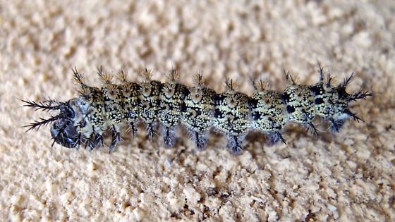
Tricolor Buck Moth (Hemileuca tricolor) caterpillar in one of its instar variations. Approx. 5-6 cm L. Host plants are mainly little-leaf palo verde (Parkinsonia microphylla) though mine was in a mesquite tree (Prosopsis articulata). Photo: © CC-BY-NC Sue Carnahan
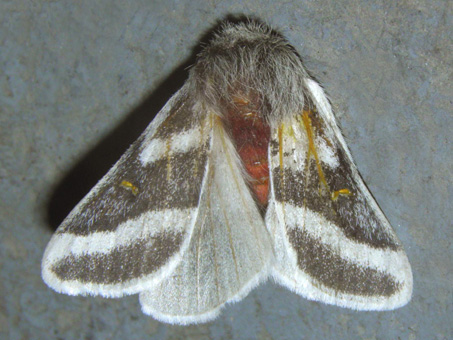
Tricolor Buck Moth, Hemileuca tricolor. Photo: © CC-BY-NC Thomas R. Van Devender. This adult male has a wingspan of 5.2 to 7.8 cm.
Perhaps you've heard the phrase: “Experience is something you don't get until just after you need it.” At this lovely site today, I had a rather painfully unpleasant encounter with a caterpillar I didn't know existed, but now will never forget! The Tricolor Buck Moth (Hemileuca tricolor) is one of a number of species known in Mexico as el gusano quemador (literally the worm that burns). I found out the hard way that these pretty, spiny caterpillars should never, ever be touched. Of course when it fell onto my back and caught in my waistband as I was bending down under a mesquite tree, I didn't know what it was that was burning the heck out of first my back, and then my hand right after I had reached back blindly to remove it.
I spent the rest of the day (we were only an hour into an all day expedition), gripping one frozen ice bottle after another, my fingers painfully swollen and on fire, all while trying to collect moss and fern specimens, balance on wet rocks without my walking stick, take photos, carry on a coherent and immensely interesting political conversation in Spanish with new acquaintances at one of the ranches we visited, and hold on to the buggy as we swooshed around bends. Not a particular experience I ever want to repeat nor one I will forget.
At the time, the only evidence of my assailant was the 10 or 12 tiny, spiny clusters Javier removed from my back. We didn't see the creature and at the time, neither of us knew what had stung me. It wasn't until later when talking with the people at Rancho El Aguajito that the culprit was confirmed. I've seen the moth before, a couple of them just last fall, but never the caterpillar, so I had to look it up on Bugguide.net and Butterflies and Moths of North America as soon as I got home. The spiny clusters made sense once I saw the photos of the caterpillar. I even came across a case reported briefly in the New England Journal of Medicine about someone stung by this caterpillar!

Just a few hundred meters up the road from the stream there was a seep on the hillside next to the road. A lot of water trickled down the face and ran across the road where it coalesced into a small stream that continued downhill to feed the Vado de la Virgencita.

We've crested that first big grade and are heading towards the next.

Another sweeping downgrade surrounded by green. The road was lined with the endemic shrub Brongniartia peninsularis (Fabaceae). At speed, it took me awhile to identify them.

Brongniartia peninsularis. The leafy shrubs were dotted with what looked from the road like small orange lanterns. This was the first time I'd ever seen the flowers (2 cm L) since I began botanizing in 2001.

Another crossing of the same arroyo we were following.

The panteón at San Miguel. The cemetary is situated next to the ruins of an old church site in the bottom of a valley.

So much water. Cows and horses were happy...

This north-facing, rocky outcrop looked promising as a moss and fern habitat, both because of the deep shade and type of rock that differed from most of the surrounding lava.

And as I'd hoped, there they were! The ferns...

Heading home, tired, but still impressed by the greenery...

The dirt and rocks of the vertical road cut were covered in mosses, some young plants of a common monkeyflower (Erythranthe floribunda) & a hanging garden of sedges (possibly Cyperus dioicus) that resembled the houseplant known as Spiderplant, with new plantlets sprouting from the nodes and hanging in the air.

Riding along the large arroyo here. Everything is loaded with leaves.

Entering the thick vegetation of a bajada (alluvial fan). Lomboi (Jatropha cinerea) was the major dominant shrub in these habitats.

Brongniartia peninsularis. The pea pod is thin, hard, shiny, and about 5-8 cm L. To me, the leaves and bark have a distinctive, somewhat unpleasantly pungent odor that makes ID easy among the many leguminous trees. The bark is reddish brown.

A lush wetland area along the arroyo bed and a nearby ramada (shade). Rushes and sedges (Cyperus and Eleocharis spp.) along with Bacopa monnieri and several composite hydrophytes (Chloracantha spinosa, Ambrosia monogyra, A. ambrosioides) were thriving here.

The walls of the church & rock piles marking older graves. Almost all of the graves, except for the most recent few, lack names or dates.

...and ranchers were happy that there was a lot of forage.

The rock was cracked and broke into narrow slabs. A prickly pear (Opuntia sp.) grows right out of the rock like a rack of antlers rooted in a crack. Arching above is a wild fig (Ficus petiolaris).

...and mosses (the reddish brown & olive green patches, bottom left).

...and scale of the rugged landscape.
I was very pleased with the outcome of this trip. If bryologists awarded merit badges to their neophytes like the Boy Scouts do, I definitely earned my Eagle Badge on this excursion, having continued my quest one-handed despite being in distress, all while simultaneously honing my bryophyte prediction skills (that rocky outcrop had certainly caught my eye as promising), and successfully making seven moss collections. I also collected Pringle Lip Fern, (a new-to-me species) which apparently is known on the peninsula only from this area (Rebman, et. al 2016). And most importantly, I learned about a not-so-nice caterpillar, one that I'm likely to meet again, so now I know I should alway keep my shirt tucked in when I'm in the field!
See plant images

See more scenery
 .
.
That's it for this month. Next month I'm going to write about our November trip to Mision Santa Gertrudis in Baja California (Norte) for the Fiestas Patronales (Patron Saint's Day celebration) and another moss hunt. Until then, hasta la próxima…
Debra Valov—Curatorial Volunteer


 in the Baja California Plant Field Guide (Rebman & Roberts 2012).")