BEE FEB 2019
Misión Santa Gertrudis, BC
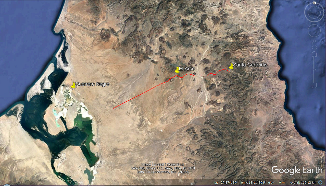
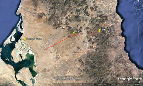 Friends of ours from Guerrero Negro have been inviting us yearly since at least 2010 to the patron saint celebration (Fiestas Patronales) for the Santa Gertrudis Mission, celebrated usually November 14-18th. This year our calendars finally coincided and we were able to go. The mission is located about 73 km from the Transpeninsular Highway and only about 8 km north of the 28th parallel. To get there you take the graded road 35 km (21.7 miles) northeast to El Arco and from there you continue on a dirt road, sometimes graded, for about 37 km mostly due east to the mission.
 in the Baja California Plant Field Guide (Rebman & Roberts 2012).")
The mission is located in Cañon de Santa Gertrudis, on the edge of the Sierra Santa Agueda. The area is within the Valle de los Cirios Protected Area and just north and outside of the Vizcaíno Biosphere Reserve. It could be best described as being in the middle of nowhere in Baja California's Central Desert ecoregion. There are a number of ranches in the area. As the crow flies, it is approximately 30 to 40 km from the Gulf coast over the Sierras.
The passage of the late summer hurricanes Sergio in mid-October and maybe the edges of Rosa in late September had left the desert bursting with greenery. Sergio's legacy was seen specifically closer to the highway from around Km 90 N. of San Ignacio to the El Arco turn and about 5 to 10 km inland from the turnoff.

Wild flowers were carpeting some stretches of the plain, both before and after the turnoff. These were the sprouts we'd seen when we went south in late October. Now, many of them were 8-12 cm high and full of blooms (and herbivores).

Sand Verbena/Alfombrilla (Abronia gracilis, Nyctaginaceae) with Vizcaino Sun Cup and Crystaline Iceplant/Hielitos (Mesembryanthemum crystallinum, Aizoaceae, a non-native).

A variety of new sprouts: Dune Milkvetch (Astragalus magdalenae, center), Onyx Flower, Wooly Plantain and Southern Sandbur/Huizapol (Cenchrus palmeri, Poaceae).

The White lined Sphinx Moth has highly variable caterpillar stages.

Once off the highway, the graded road to El Arco is very straight and crosses eastward over the Llano del Berrendo.

The Llano del Berrendo is a flat, sparsely vegetated area with sand dunes and wildflowers beginning to sprout.

View south of the Llano Berrendo from the grade, looking towards the Sierra San Francisco.

In town, the road branches, the major road continuing NE towards El Barril and San Francisquito on the Gulf Coast.

The road to Santa Gertrudis was in very good shape because, as our friends assured us beforehand, a lot of work had been done in preparation for the fiesta.

Volcanic bajadas...

...long stretches through sandy plains or arroyos...

...and past volcanic mesas.

One crossing of a very rocky arroyo bed. The tall trees are Palo Blancos (Lysiloma candidum, Fabaceae), at their northern extreme around here.

Squeezing through the looming cardonal. It was a desert version of driving through the California Big Trees.

Vizcaino Sun Cup (Eulobus sceptrostima, Onagraceae). An endemic evening primrose.

Wooly Plantain (Plantago ovata, Plantaginaceae), with sprouts of Onyx Flower (Achyronychia cooperi, Caryophyllaceae).

Likely an early instar of the White-lined Sphinx Moth (Hyles lineata), a common desert moth munching its way over Peninsular Dyssodia/Hediondilla (Boeberastrum anthemidefolia, Asteraceae) and possibly Amaranthus obcordatus (above caterpillar).

There were at least these three color variations, but I didn't look more closely to see if there were more. They were out in droves.

The road to El Arco is well-maintained up to the town, no doubt because of the mining interests. We encountered no other cars.

Surprisingly, the road gains about 200 m elevation by the time you reach a small grade just a few km from town.

El Arco is a tiny town where the Grupo Mexico company has been planning to start copper mining.

Most of the original adobe buildings are in ruin.

It was a one lane dirt road that passes through a remarkably diverse landscape:


...a few twisty bits up through rocky outcrops...

The Cardón forests (cardonales) were the densest we'd ever seen.

Passing through the cardonal. Some of the plants between the cacti include: Palo Adán (Fouquieria diguetii), Lomboi (Jatropha cinerea), Mesquite and Desert Ironwood (Olneya tesota)

Approaching Santa Gertrudis, with the late afternoon sun casting shadows and giving depth to the canyon walls.
Additional plants not mentioned in the text include: Galloping cactus (Stenocereus gummosus) and Desert Yaupon/Sarampion (Schaefferia cuneifolia) foreground; and Wax-Slipper Plant/Candelilla (Euphorbia lomelii).

Cardóns were massive.
Once into the higher desert between El Arco and Santa Gertrudis (surprisingly the same elevation as the Sierras behind Mulegè, 250-450 m) there were fewer flowers but all the plants were heavily leafed out.
Taking an inventory as we went, I noticed that the most common plants we were seeing were basically the same as those found in Mulege: Lomboi (Jatropha cinerea), Elephant trees / Torotes (Bursera microphylla and B. hindsiana, Palo Adán (Fouquieria diguetii), Mesquites (Prosopis articulata and P. palmeri), Creosote /Gobernadora (Larrea tridentata), Palo Verde (Parkinsonia microphylla), Chain-link Cholla (Cylindropuntia cholla) and Cardón (Pachycereus pringlei). Most can be seen in the photo to the right.
However, there were at least two endemic plants common to the area (but which are not found on the Gulf Coast): San Francisco Agave / Maguey (Agave cerulata var. subcerulata) and Datilillo (Yucca valida). A third species, Long-spine Cholla / Clavelina (Cylindropuntia molesta var. molesta) may occur along the Gulf, but at least not in the Mulegé area.
The Mission
Misión Santa Gertrudis la Magna de Cadamán was founded in 1752 by Jesuit missionaries and the cut stone building was completed in 1796. It was built exploiting the labor of the local indigenous Cochimí people, from whom our friends descended. Read more about the history.
We stayed 2 nights in Santa Gertrudis in a very rustic cabin, sharing meals with our friend, his mom, uncle, brother, and another friend. While neither of us were into attending the morning or evening mass or dancing into the wee hours of the night, we did spend time walking around the village, checking out the mission and its museum, and looking at the plants present in the area.

Downtown Sta. Gertrudis. The store (front) and cabins (rear & left).

The rock, piedra de cantera (quarry stone), was hewn with hand tools, the marks still visible.

The view from behind the mission of the east wing. The building is built in the shape of an L with walls about 50 cm (18") thick.

One of the two small museums is located inside the mission.

Alter to Santa Gertrudis, located outside at the rear of the mission.

Procession of parishoners, bearing the statue of Santa Gertrudis as they pray.

Mision Santa Gertrudis la Magna de Cadamán.

It was excavated and hauled from this hillside just east of the mission.

The ruins of a separate building towards the SE, near the belltower.

It has artifacts and histories of the local families.

Santa Gertrudis herself. These statues are often transported between village churches where they "visit", and are then carried back to the namesake mission, often accompanied by a cabalgata (procession of horseback riders).

The cabalgata has just arrived (a couple of hours behind schedule) after about a 30 km ride from a "nearby" ranch. By this time, many of the cowboys had already had one beer too many. There were cowgirls, kids and babies on some of those horses too!
Since this was our first trip to Santa Gertrudis, I didn't know what to expect geologically or botanically. I was surprised to see at least two granite boulder fields, one along an arroyo and the other within an otherwise volcanic lava mesa and slope. Their presence motivated me to look for moss and ferns, given last month's moss/fern finds at around the same elevation.
Hike in Arroyo Santa Gertrudis

View from near the mission, looking into the arroyo towards the SE.

On my first outing along the arroyo in the late afternoon, I weaved in and out of rocky pockets, marveling at the enormous boulders...

Wild fig / Zalate (Ficus petiolaris) melded into the granite. The lower root system appears separated...

Lots of big boulders in the arroyo. Locals say that the arroyo is now much wider and has less water in the pools (tinajas) since the flash floods 2013 to 2015.

... & their companion plants, these often growing from cracks in the surface: Lomboi, Torote, Fig.

...but does support the living fig tree above. It was difficult to tell root from rock in many places.
The scenery was great, but when I was just about to give up after climbing under and around bushes for about an hour looking for moss, my eye was finally drawn by a promising hint of green in a vertical rock crevice formed by two enormous boulders. Mostly the green had proven to be lichens that afternoon, but this time it was a patch of olive green moss about 20 cm long and 2 cm wide. Victorious! I took my photos, made my collection, and headed back to base.

The crevice was about 1.5 m (4 ft) above the ground.

The moss wet, at about 10-12 x under the microscope.
Granite/Lava Mesa
Back in camp but feeling restless and amazingly reinvigorated after a small rest, I decided to check out the mesa just above where we were staying. Up the short, rugged trail, into the dense scrub, and the odd mixture of lava and granite.

Granite outcrop just on the edge of the town & a new quarry rock wall.

Intermingling of granites and many types of volcanic rock.

The trail was fascinating: eroded channels through packed rotted granite. This whimsical ballerina (Bursera microphylla) made me laugh.

Up on the outcrop/mesa. The granite is mixed in with lava cinders.

View of the mission from up on the mesa.

A slice of life up on the mesa (clockwise from top): Torote, Palo Adán, Chain-link cholla, Organ-pipe cactus/Pitahaya dulce (Stenocereus thurberi), Long-spine cholla, Flor de Campo (Ruellia sp.). A tiny Mammillaria is hiding in there somewhere too.
The trail was clear and once up on the top it was easy going to wend my way through the granite boulders. The view was spectacular. On that hike I found lots of colorful lichens and one patch of ferns. But no sign of any moss.

An unidentified dried fern. Not very attractive in this dry state though it looked a bit like octopus arms.

Up on the outcrop/mesa looking NW in the late afternoon. In the middle distance are some farms and then the arroyo bed. The area was like a well-maintained botanical garden.

Barrel cactus/Biznaga (Ferocactus sp.)

Up on the outcrop/mesa again, this time in the morning. This continues the view from the photo on the left, farther up the arroyo in the direction we came.
I was convinced there had to be moss in this area. It was a dry habitat very similar to that in Cataviña where I'd found mosses at a number of boulder sites, a few even growing right on top of the boulder in full sun! With the light failing, I set myself to return the next morning to continue the search.
The next morning when I returned, I must have scoured the north side of every boulder up there. I gradually made my way up the slope and traversed the entire hillside. And not a single moss to be found – though I did find another species of fern.


Hot and tired, I was ready to give up the search when I took a look at just one last boulder before planning to head back down (my partner had already given up an hour earlier, and was hanging out on the mesa below, keeping an eye on me). And there, on its north side, I found a promising patch. However, having forgotten to pack my hand lens, and with only my distance glasses to see, it was all a blur to me. I did the next best thing to test for moss – I sprayed the suspect patch with a mouthful of water – and it sprang to life, immediately spreading open and turning green. Moss!? I scraped off the sample into a collection packet and headed back down the hill. The more my brain ticked over, the more dubious I was that it was a moss. I’d have to verify back at base camp.

What could be moss mixed in with the lichens...

Definitely lichens nearby.
Back at the bottom of the boulder fields, still up on the mesa, I had just stopped to catch my breath, take a drink of water and open a snack, when my eyes fell on a grayish, velvety patch on the boulder right next to my backpack. I couldn't believe it! A patch of what was unmistakably moss (below, left). An almost invisible and much thinner layer of moss than what I had found before in Cataviña or the Sierra San Francisco. This probably explains why I hadn't found any until here until now – I was expecting something much thicker that stood out more.

Can you find the patch of moss in this photo?

Or in this one?
And of course as I headed back to meet up with my partner, I passed a 2nd patch of the same moss (above, right)! Ironically about 12 inches away, and under a small ledge, from where I had taken a picture of a bright orange and yellow patch of lichens the evening before. I´m blaming my glasses!
I yelped with satisfaction at having found more moss and, with a big smile, headed back down the hill to base camp. Short-lived victory. Under the hand lens, my first collection proved not to be a moss, but very leaf-like squamulous lichen.
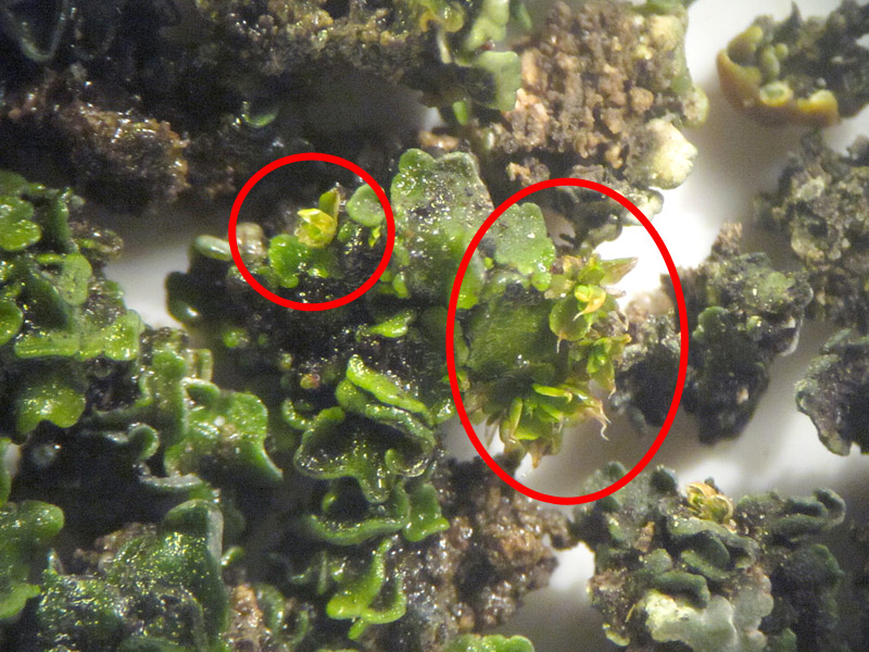
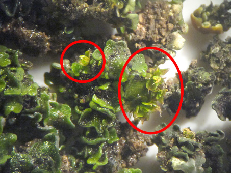 Nonetheless, I was feeling quite content about the small success that I'd had finding both moss and ferns in Santa Gertrudis. I had collected two moss species and had seen two fern species as well. The cool thing is that when I returned home and checked the squamulose lichen under the microscope, at first I only saw small blackish balls of tightly packed dry lichen, but when these were wetted they turned green and quickly unfurled to reveal small leaf-like, overlapping thalli…and some tiny, individual moss plants tucked carefully inside (circled in red)!
That's it for this month. I have no idea what next month will bring. So, until then, hasta la próxima…
Debra Valov—Curatorial Volunteer
. Copyright © 2018 D. Valov")
 in the Baja California Plant Field Guide (Rebman & Roberts 2012).")