
MFP — Mulegé Flora Project
MFP Home | Locations | Geomorphic Formations | Plant Taxa
Locations
The town of Mulegé is located on the coast of the Gulf of California, and the study area includes the town and the valley to the west. It also extends northward to the small town of San Bruno, northwestward to encompass Punta Chivato, and southward along Bahía Concepción as far as Playa Armenta.
Inland, descending from the mountains to the west of the study area are gentle sloping alluvial fans criss-crossed by dry watercourses that originate from larger canyons and gullies in the mountains. The Mulegé valley is a huge alluvial flow that descends gradually to sea level, disgorging into the Mulegé estuary and the Gulf of California. Along the freshwater portion of the river is a palm oasis. Sandy beach strands and dunes can be found along the coast of the gulf as well as within Bahía Concepción to the south.
Below are images that give a broad overview of the area, from the northern limits of the study area near San Bruno to the southern limit at Playa Armenta, Bahía Concepción, and the eastern limits in Punta Chivato to the western limits in the Mulegé valley.
For more field notes related to the Mulegé area as well as outlying areas and locations further afield on the peninsula, be sure to visit my blog entries covering late 2012 to present, available at Notes from South of the Border.
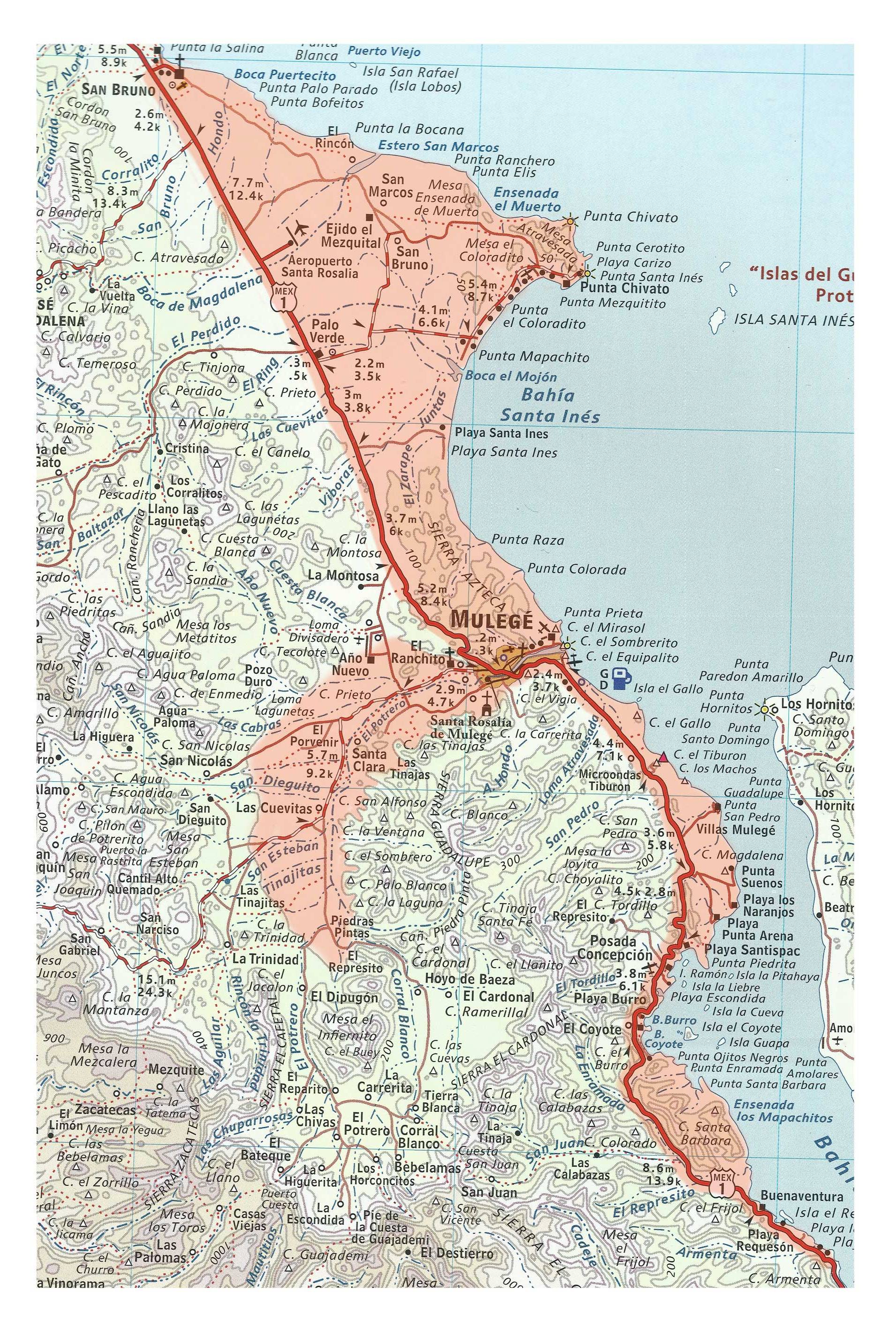
Map of the Mulegé area with the limits of the study area in orange. Adapted from: Crumpton 2009. The Baja Almanac.

Looking west from near Hwy 1 just before the Las Plumas grade (that climbs through the Sierra Azteca and descends into Mulegé from the north). The many small hills leading up to Sierra Guadalupe can be seen in the distance. The dirt road leads towards Rancho Año Nuevo.

Hills that form the Sierra Cardonal on the south side of the river and of town. This photo is from the area known as El Rastro. A road from the neighborhood El Rebaje passes the rastro (abbatoire) and...

...continues along the edge of the hills, as far as La Ventana (a window rock). An alkali sink forms part of the small valley (behind the camera). Images Nov. 2012, two months after Tropical Storm Paul.

The beach at San Bruno, the northern limit of the study area. It has very low dunes with some areas of high impact from local vehicles. Isla San Marcos is in the distance. The white patch low to the water on the right side of the island is the gypsum mine.

Estero San Marcos is a large estuary located between San Bruno and Punta Chivato along the Gulf coast. It is fed fresh water only in times of heavy rains on the plain behind.

Gulf coast from the Dolphin Cove real estate development, looking northward across the dune field on the north side of the Punta Chivato peninsula. The mountain range in the distance is the eastern escarpment. This section of the peninsular ranges, that extends from near Mulegé to around the town of Santa Rosalía is known as the Sierra Guadalupe.

Isla San Marcos as seen from the Dolphin Cove development on the north shore of Punta Chivato. What looks like pale cliffs is actually primarily the exposed excavation sites of the gypsum mine on the southern part of the island.

Beach on northern coast of Punta Chivato, where there is a small real estate development called Dolphin Cove.

Looking NW along one of the two small beaches between Punta Chivato (at far right) and Punta Cerrotito (south, behind camera).

Looking SE along the other small beach between Punta Cerrotito (pictured) and Punta Chivato (north, behind camera). The peninsula is of uplifted limestone with overlays of volcanics. These two beaches (this and previous photo) face E and are open to the full force of the the Gulf & wind. Dunes have been created against the cliffs in this stretch and extend beyond the tops of the cliffs, where they have also engulfed a small volcanic knob on the far right, out of frame.

One field trip around Punta Chivato was aided by local expats who took the author on some local back roads. Here, looking south from the base of Punta Cerrotito towards Punta Cacarizo (the dark strip at center along the water's horizon, known by English-speaking residents as Hammerhead Point). The flat place just above it is the mouth of Bahía Concepción, with the Concepción peninsula on the left, and the Sierra Azteca the nearest hills on the right.

Looking back at Punta Cerrotito from the spit between the mainland and Punta Cacarizo. The volcanic plug engulfed by dunes is on the left.

Punta Cacarizo is a mostly barren chunk of limestone. The surface rocks are heavily pockmarked. This is a view mostly southward towards Mulegé. The land in the near distance is one of the Santa Inés islands, also made of limestone and with a low profile.

Punta Mezquitito (the fourth point on the Punta Chivato peninsula) as seen from Punta Cacarizo.

Looking northward from the beach at Punta Prieta (Mulegé), towards Punta Chivato in the far distance, with Punta Colorado the last clearly visible feature at the curve of the beach and cliffs.

El Gallito beach, running southward towards the Mulegé river. An extensive dune field is to the left. Read more about the dunes.

View of Cerro el Gallito, looking northward from Tiburón grade. El Gallito dunes are in the mid distance. The Punta Chivato peninsula is just visible on the horizon left of El Gallito.

Eastward to Bahía Concepción & the Concepción peninsula from Cerro San Pedro. Playa los Lobos is between the cactus stem & small hill.

Playa Los Lobos, a pebbly beach near the mouth of Bahía Concepción. The Concepción peninsula is the backdrop.

Rocky bluffs at Punta Sueños just within Bahía Concepción.

View northeastward of the bay, Punta Arena and the peninsula.

Palm palapas on narrow beach strand at Playa el Coyote. One of the mountain ranges of the peninsular escarpment drops here into the sea.

A narrow beach strand and vacation homes at Playa el Coyote. The Mulegé Valley lies almost due west just a few kms behind these hills.

View of Coyote beach and bay, within Bahía Concepción.

View northeastward of Bahía Concepción, taken from Isla Coyote. The western shore and Sierra Gavilanes is in the background. Several islets are also visible. The mouth of the bay is just out of view (top L).

Playa Armenta, the southernmost point within the study area.