
MFP — Mulegé Flora Project
MFP Home | Locations | Geomorphic Formations | Plant Taxa
Geomorphic Formations
Geomorphic formations identified for the Mulegé Flora Project include the following: arroyos or seasonally dry water courses (including canyons, gullies and washes); bajadas or alluvial fans; beaches and dunes; ancient seabeds with gypsiferous secondary deposits; hillsides and coastal bluffs; the Mulegé arroyo valley; coastal wetlands (salt flats, salt marshes, coastal lagoons, and estuaries); and riparian areas, most specifically a freshwater river with oasis.
Below are more images of geomorphic formations found in the Mulegé area: Arroyos | Bajadas |
Beaches and Dune fields | Gypsiferous soils | Coastal Wetlands | Hillsides and Bluffs | Palm Oasis | Mulegé Valley
Click on any image for an enlarged view. All photos by the author.
For more field notes related to the Mulegé area as well as outlying areas and locations further afield on the peninsula, be sure to visit my blog entries covering late 2012 to present, available at Notes from South of the Border.
Arroyos (including seasonally dry canyons, gullies and washes

Well-vegetated arroyo near Playa Punta Arena.

Well-vegetated arroyo near Playa Punta Arena.

Rocky arroyo and cliff wall, west side of highway behind Colonia Vista Al Mar (Nuevo Mulegé). Common arroyo trees are Lysiloma candidum, Prosopis articulata & Olneya tesota. Cliff dwellers here include: Hofmeisteria fasciculata var. fasciculata (the numerous pale green rounded mounds on rock walls), Eucnide aurea & Echinocereus brandeegei (Apr. 2018).

Gravelly, sandy arroyo in southern part of the Mulegé valley. Trees: L. candidum, O. tesota & P. articulata.

The bajada here near Punta Prieta has fine but heavy volcanic soil strewn with volcanic debris. There are several small gullies cut by runoff that support an increased variety of shrubs and trees, including Lysiloma candidum, as well as larger specimens of Bursera and Fouquieria spp. (Mar. 2005).

Bajada near Punta Prieta. Dominant species include: Cylindropuntia cholla, Bursera hindsiana, B. microphylla, Fouquieria burragei, F. diguetii, & Jatropha cuneata. Other species: Lycium andersoni var. pubescens, Olneya tesota, Schaefferia cuneata, Ruellia californica subsp. californica & Prosopis articulata (Nov. 2011).

Understory of the Punta Prieta bajada in many areas consists primarily of the perennial dyeweed Marina parryi, here still quite dry after a fairly dry summer. Both Cylindropuntia alcahes var. alcahes and C. Cholla are pictured, as are Pachycereus pringlei and Parkinsonia microphyllum (Dec. 2012). Here's more about the Chollas.

Punta Prieta bajada after a wet summer (Nov. 2013). Columnar cacti are Pachycereus pringlei (Cardón). Find out more about this species. And see more taxa from this area.

The bajadas in the Mulegé valley, especially closer to the surrounding mountains to the west, have much deeper soils and the plant specimens reflect the increased moisture and nutrients available. A Fouquieria diguetii towers over the author. In other habitats, the Fouquieria are shorter and less robust (Mar. 2012). Here's more about Fouquierias.

Densely vegetated bajada on the west side of the highway opposite from Playa Coyote. Vegetation is usually denser and cardonales (large stands of Cardón) are more common in bajadas. Red flowers are from Palo Adan (tree ocotillo, F. diguetii) (Mar. 2018).

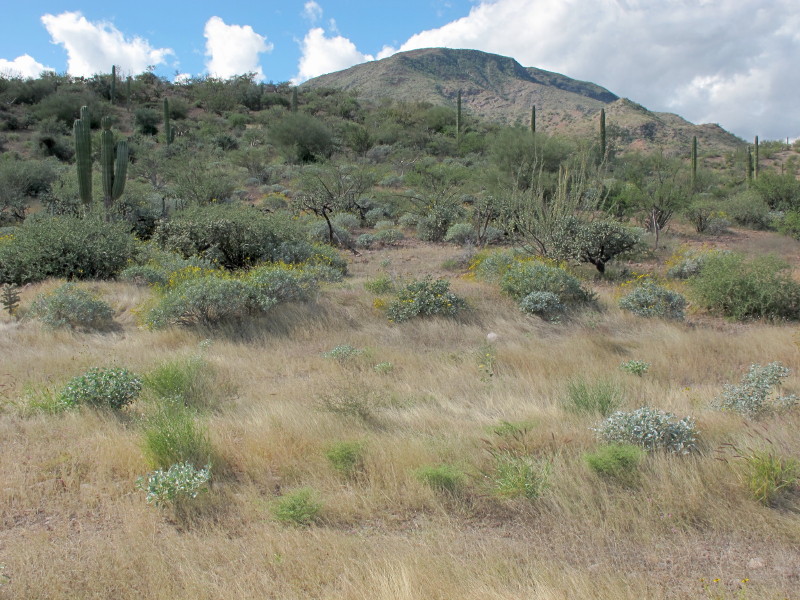
Lower edge of a bajada near Playa Punta Arena as it is about to meet the transition zone to salt flats (Nov 2017). Vegetation is notably shorter and less robust here in this area with shallower, more alkaline soils. Columnar cacti (Stenocereus gummosus) in the foreground are flanked by Ruellia californica subsp. californica (on L) and Bebbia juncea var. juncea (on R).

Dune field on side of a volcanic outcrop at Punta Chivato, the sand wind-driven by the prevailing northerly winter winds. A large number of the plants show salt-spray pruning and wind-sculpting (Krumholtz formations) due to the strong winds along this exposed coastline.

Densely vegetated rear dunes at Playa Santa Inés. Some areas are impassible on foot due to the cactus thickets and thorny shrubs such as Condalia globosa var. globosa, Lycium brevipes, F. diguetii and Prosopis articulata. Other common species include Jatropha cinerea, Euphorbia lomelii, and Maytenus phyllanthoides.

Foredunes at Playa Equipalito, on the south side of the Mulegé estuary. Dunes here are flat and about 1-1.5 m above the mean tide line.

Dune species at Playa Equipalito include Palafoxia linearis, Abronia maritima, Psorothamnus emoryi var. emoryi, Nicolletia trifida, and Gundlachia diffusa.

View of Cerro El Gallito and the large dune system that surrounds the outcrop. Foreground is typical desert bajada scrub. South of Mulegé (May 2005).

Looking towards Mulegé across the El Gallito dunes. The dune vegetation ranges from open and sparse to dense and almost impenetrable (Nov. 2017).

Where the desert meets the sea. Mangroves on the pebbly beach. A cove just south of Playa El Coyote. Native summer annual grasses make up the yellow-tan ground cover (Nov. 2006).

Dense dune field behind Playa La Perla along Bahía Concepción. Stenocereus gummosus and Condalia globosa var. globosa (foreground), Prosopis articulata & Pachycereus pringlei (behind) (Nov. 2013).
Punta Chivato Gypsiferous Areas
This location is on the southeast side of the Punta Chivato peninsula in a relatively small area. As the photos show, the soil is a bright, grayish white or yellowish-brown. This area is an uplifted ancient seabed that now has secondary deposits of gypsum. There is a rich gypsum mine offshore to the north on Isla San Marcos.

The vegetation consists of desert scrub typical to the region, with a few exceptions, like Euphorbia ceroderma, the rounded shrub in the lower left which locally is only found in this area. The species is more common on the opposite side of the Gulf in the state of Sonora. It is disjunct on the peninsula with populations along the Pacific coast around San Juanico and the Comondús.

Moving backward: Jatropha cuneata, F. diguetii, Cylindropuntia cholla, Larrea tridentata, Bursera microphylla, Euphorbia ceroderma and more F. diguetii.

Moving backward: Euphorbia ceroderma, Ruellia californica subsp. californica, Jatropha cInerea and F. diguetii.

Dominant species pictured include Euphorbia lomelii (foreground), E. ceroderma (middle) and Fouquieria diguetii (right and center rear).

A shallow coastal lagoon at Playa Punta Arena. Species: Allenrolfea occidentalis, Arthrocnemum subterminale, Avicennia germinans, Batis maritima, Distichlis littoralis, Maytenus phyllanthoides, Salicornia pacifica and Sesuvium portulacastrum.

Mangroves and salt marsh at the edge of the beach. Allenrolfea occidentalis is the low shrub on left side. Mangroves represented by three species: Avicennia germinans (Black Mangrove), Laguncularia racemosa (White Mangrove) and Rhizophora mangle (Red Mangrove).

One of the larger mangrove forests is here, at Playa Santispac. All three mangrove species are well represented. Red mangrove is usually at the edge of the water, but White mangrove can also fill that niche, esp. where there are few Reds. Black mangrove commonly occurs towards the rear, where its pneumatophores are exposed to the air at low tide.

Playa Requesón with its small island connected by a sand spit that is exposed at low tide. Mangroves line portions of the two inlets on the north and south of the spit. Foreground plants: Cordia parvifolia with the white flowers; the rounded gray-green shrubs are Brittlebush (Encelia farinosa var. phenocodonta).

The beginning of the Mulegé estuary from the top of the bridge. Note the dense mangroves, especially on the left behind the Phragmites and Arundo (May 2005).

Same view in Dec. 2013 after two major floods. There are no mangroves larger than a seedling. Many palms were lost on both sides of the river. Arundo and Phragmites dominate the left bank in 2020.

Looking up the estuary from the mouth of the river at the lighthouse in Jun. 2005. Click for an enlarged image in which the mangroves lining almost the entire estuary are visible. The large gravel bar in the middle is thick with mangroves.

Click to enlarge this 2012 image and note the large white patches along the banks where mangroves have been lost. Note too the loss of the gravel bar and its few mangroves. The situation in 2019 is even worse.

A closer view of the photo above from 2005. Few of the mangroves on the far left shore opposite the gravel bar remain in 2020.

The same view in Mar. 2017. The long white shoreline is now a paved road. See Plant Taxa for more on the changes along the river.

Arroyo Mezquital and a slice of Bahía Concepción. Exposed, rocky, south-facing slopes are usually sparsely vegetated.

Sierra Azteca, the low but steep range on the north side of H. Mulegé. An deep narrow arroyo (not visible) winds its way up into the hills from La Huerta Don Chano.

The steep hills surrounding H. Mulegé. The town is hidden from view and in the valley behind the white structure visible on the hilltop.

Low ridge behind Punta Sueños, along Bahía Concepción. North and northeast-facing slopes are commonly densely vegetated, especially with Brittlebush (Encelia farinosa var. phenocodonta), as seen here. See some of the plants of a coastal bluff.

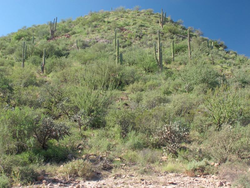
Even rocky cliffs are home to an amazing collection of cactus and trees clinging to their sides. Here, Cardón, Elephant trees (Bursera spp.) and an Old-man cactus (Lophocereus schottii).

Palo blancos (Lysiloma candidum), young cardóns, a barrel cactus (Ferocactus peninsulae) and some tiny elephant trees call this cliff home.
Another densely vegetated northeast-facing slope with Brittlebush, Elephant trees (Bursera spp.), Fouquieria diguetii and Cardón. Near Arroyo Mezquital (Nov. 2013).

A volcanic hillside with a tuffaceous outcrop near Punta Arena. L to R: small Bursera microphylla and Cardón, B. hindsiana and Organ-pipe cactus (Stenocereus thurberi).

A more easterly-facing rocky hillside at Punta Sueños at the coast is a little less densely vegetated than its northeast-facing neighbor nearby (Nov. 2017).

Rocky hillside near Huerta Don Chano on the north side of the river.
Hillside between El Rastro & La Ventana, Mulegé Valley (Nov. 2012) a month after the remnants of Hurricane Paul drenched the region.

The same hillside from a slightly different angle four months later. (Mar. 2013).

The iconic view of the Mulegé Oasis from the Mirador (vista point) at the Mulegé Mission (May 2005). Looking west to the Sierras.

Mulegé Oasis view in Nov. 2012. Some loss of palms with more Arundo & Phragmites after flooding from hurricanes John, Jimena & Paul.

Mulegé Oasis view in Apr. 2014. Arundo & Phragmites getting higher and moving deeper into the palm orchard.

Mulegé Oasis view in Mar. 2018, showing loss of some of the left bank plus more palm loss on the right and healthy Arundo & Phragmites.
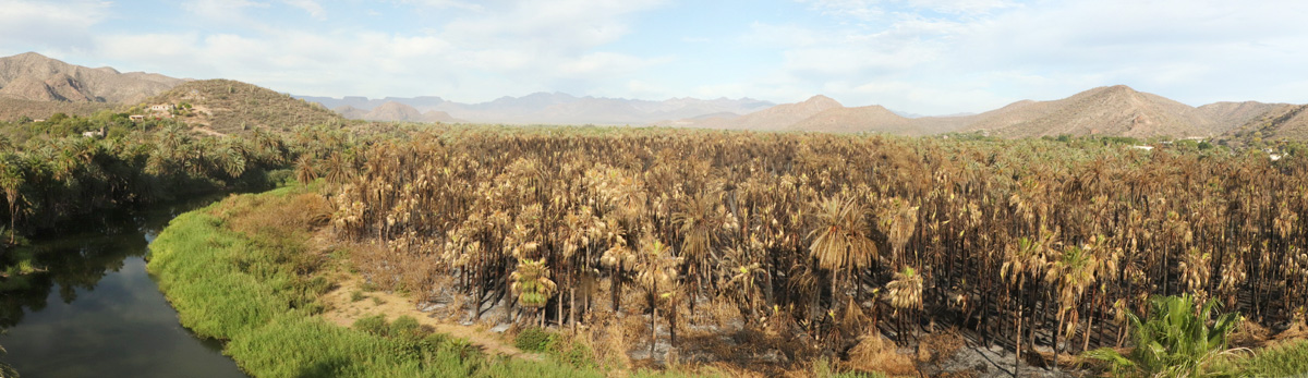
Mulegé Oasis view in May 2020, a few days after fire passed through the orchard. The orchard was still smoldering in places when this was taken.

While looking for mosses, I came across this ditch on the western edge of the Palm Oasis in Nov. 2012 after Hurricane Paul. The banks were thick with a number of bryophyte species and over the next few years, it was an excellent collection site for some of the hydrophytic species of the palm oasis. More about this site is available starting on this page.

The same location in Nov. 2015. Unfortunately, the flood control project cut a large swath through the area, completely destroying the perfect collection site. However, life goes on and the area saw a new development starting in mid 2018.

That's when town officials started to let the water behind the dam rise almost to the top, resulting in a deeper river and more water percolating to the surface in places like this trenched path through the oasis (Nov. 2018).

The cattails (Typha domingensis), Bulrush (Schoenoplectus americanus), Salt Cedar (Tamarix aphylla and T. ramosissima) all just about tripled in number and height in only 4-5 months along the ditch, now a new freshwater wetland (Apr. 2019).
El Ojo de Agua

Ojo de Agua (headwater) of the Mulegé River (Mar. 2011, view #1). The water bubbles out of the ground just right of the author's shoulder.

Ojo de Agua (Nov. 2011, view #1). The vegetation was opened up a little after a small flash flood at the same site.

Ojo de Agua (Jan. 2013, view #1). The Ojo was opened up even more by flooding from Hurricane Paul in Oct 2012. Water could be seen bubbling up from the river bed along this section, now about 4-5 m wide. The bottom is deceptively deeper than it appears.

Ojo de Agua (Mar. 2015, view #1). A govt. project in late 2014 resulted in the felling of a large swath of palm trees. The machines dug too deep, exposing the high water table and resulting in a new wetland area forming over about six months.

Ojo de Agua (Mar. 2017, view #1) from same spot as in 2011. The wetlands spread up the excavated area, some parts were swept away again in 2015 by Hurricane Odile but began later to grow back.

Ojo de Agua (Nov. 2018, view #1). The author returned to find that the wetland area had been completely flooded when the dammed water was allowed to back up to max. levels in summer 2018.

Ojo de Agua (Nov. 2011, view #2), same site but looking downstream. The channel was very narrow & full of Arundo & Phragmites.

Ojo de Agua (Jan. 2013, view #2). Like in the upstream view above, the channel was widened by flooding in 2012 from Hurricane Paul.

Ojo de Agua (Feb. 2015, view #2).

Ojo de Agua (Nov. 2015, view #2).

Ojo de Agua (Mar. 2017, view #2). The channel was cleared out and widened by the flood waters from Hurricane Odile.

Ojo de Agua (Nov. 2018, view #2). Showing the backed up water from the dam further downstream. Ground was wet deep into the oasis.

Hydrophytes at Ojo de Agua, site #1 at their peak growth in Feb. 2017. The most common species were: Stemodia durantifolia var. durantifolia, Amauria rotundifolia, Bacopa monnieri, Typha domingensis, Anemopsis californica, Eclipta prostrata, Heliotropium curassavicum var. oculatum and the invasive Nicotiana glauca.

View to west upstream from the bridge of the river and abandoned orchard on the left that has been an excellent collection site. The roof of the Mulegé Mission, which sits on a rocky bluff, is just visible above the end of the road at the top of the treeline. Tiny white triangles and a square mark the top edge of the roof (May 2013).

Freshwater lagoon below the dam, taken from under the bridge (Feb. 2009).

Same view from Dec. 2013. The populations of Arundo donax and Phragmites australis come and go with the successive floods.

View from the Mission vista point back towards the abandoned orchard and bridge (Nov. 2012).

Same view after 3 major floods in this area cleared out both palm & fruit trees & deposited large mounds of sand and gravel (Mar. 2018).

Still lots of grasses in Oct 2013 after a summer of many small storms.

Cattle & goats are the main livestock raised in the area (Oct 2013)

Inspecting the debris line in the Mesquite tree in a wash (site #3) near the dairy not long after Hurricane Jimena brought the second 50 year flood within 3 years to the valley. The third, Odile, hit 6 years later.

Farmland on the northern edge of the valley near Rancho Año Nuevo.

Natural topiaries created by dense growth of Brandegea bigelovii vines, five months after Hurricane Jimena (Feb 2010). There's a 4 m high Cardón under that center one.

There may be a Mesquite under this massive bower of vines, almost exclusively of Brandegea. The Ricinis communis (to the L) reached tree-size proportions in the valley during this time (Feb 2010).

Brandegea vines also covered large areas of the ground and supported huge populations of blister beetles and caterpillars ( Oct 2009).

Yet more Brandegea (Dec 2009). Elsewhere, vines also included Ipomoea triloba (non-native) & Cucurbita cordata (endemic).

Excavating for the canal/water diversion project in Mar. 2014. The machines moved the fine, talc-like soil into mounds to create a low bank. After the flood six months later, there was no sign of the excavations or banks of the ditch and any nearby vegetation that had been spared was also swept away.

This is the same wash (site #3) from the 2009 photo above, which here is being widened for the canal/water diversion project in Mar. 2014. After Hurricane Odile in Sep. 2014, the wash widened to over 200 m, up from about 30 m pre-2009.